
|
|
|
|
Walking to the top of Cnoc Fyrish
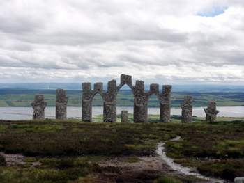
Standing tall over Alness, Cnoc Fyrish rises to 1,478 feet. The imposing monument, at the summit, was built in the 1780’s. It is said to replicate the Gates of Negapatam, a coastal fortress near Madras in India, which General Sir Hector Munro, 8th of Novar (who was raised on the estate) had captured from the Dutch and their Indian allies around 1781. On his return home from India, and as the local population were being cleared off their land, employment was a problem and so it was allegedly built to give the locals some work. It was said that Sir Hector rolled stones from the top of the hill to the bottom, thereby extending the amount of time worked and paying the labourers for additional hours. To visit the monument and see the views for yourself, you can follow the route below. You could take a taxi to the (Novar Estate) Jubilee Path car park and start your walk from there, or you can walk from Invergordon to the Jubilee Path car park, a distance of about 6.5 miles. Using our local knowledge we took a bus from Invergordon High Street to the south end of Alness where we got off the bus. (The 25X or 25 bus will take you here but to slightly different bus stops therefore it is more difficult to explain the next steps). You can follow the route required by enlarging the map under Surrounding Area/Area Map on this website and looking for ‘The Corkscrew’.
On leaving the bus and walking in the direction the bus is travelling, a short walk will take you to the Westford Roundabout. From here you take the Westford exit and take the first left (with a parking area on the right). After the parking area, and heading towards the churchyard and ruined church, take the tarmac road on the right, which takes you on to a little bridge over a stream. This is ‘The Corkscrew’ road which is single track and is used by vehicles so you have to be aware of traffic, in both directions! This road is narrow and winds uphill, but after about a mile you come to a major road (B9176), which has to be crossed and can be busy. Straight across we continued using the road to Boath, again a narrow tarmac, single track road which eventually leads to Novar Estate car park where you will see a sign for the Jubilee Path to Cnoc Fyrish. The car park seemed like a good place to stop before tackling the rugged path, so we had a quick 10 minute break. The walk from the bus stop to the car park was about 2.5 miles, the road was easy to walk on but was uphill. The length of time it takes depends on various things like traffic and your own pace.
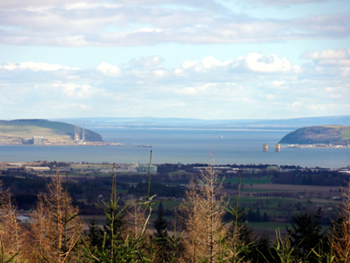
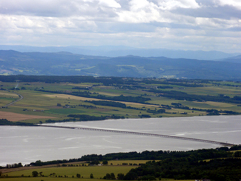
The climb from the car park to the summit is indicated as being 2 miles or 3 kilometres but it is rough in places and caution needs to be observed as it would be easy to go over on your ankle. However after all the hard walking the view from the top is quite simply stunning, making every step very worthwhile. This is definitely an all-day trip and allowance has to be made for the return trip. Give yourself enough time to descend and then catch the 25X (or 25) back into Invergordon, in time to board your ship again. More details of a suggested walk to the top of Fyrish can be found at www.walkhighlands.co.uk/ullapool/fyrish-monument.shtml Full details of local bus timings can be found at: http://www.stagecoachbus.com
|